
OVERVIEW
Updated March 2019
California Senate Bill 827 was introduced in January 2018 and was designed to incentivize housing development near major transit stops and routes throughout California. The bill, as currently written, would “upzone” properties within ½ mile of a “Major Transit Stop” or with ¼ mile of a “High Quality Transit Corridor” (defined below). These parcels would be exempt from any local controls on housing density (including floor area ratios), would remove any parking minimum requirements, and would also change maximum allowable building height limits to between 45 and 85 feet in some places.
Overall, the bill could affect large areas of major cities in California, including most of LA and San Francisco, which currently have many transit stops and routes that qualify under this bill.
Within Palo Alto, East Palo Alto, Menlo Park, and Atheron, there are three primary transit routes that qualify as high-quality transit corridors: VTA Route 22 and 522 along El Camino Real and SamTrans Route 281 along University Avenue. In addition, five CalTrain stops meet the criteria for a Major Transit Stop. Neighborhoods within proximity to these routes would be affected by possible density and/or maximum height changes as summarized below.
Definitions
Major Transit Stop: An existing rail transit station, a ferry terminal served by either a bus or rail transit service, or the intersection of two or more major bus routes with a frequency of service interval of 15 minutes or less during the morning and afternoon peak commute periods.
High Quality Transit Corridor: a corridor with fixed route bus service that has service intervals of no more than 15 minutes during peak commute hours.
Transit Rich Housing Project: a residential development project the parcels of which are all within a one-half mile radius of a major transit stop or a one-quarter mile radius of a high-quality transit corridor.
Upzoning: changing zoning to allow for higher densities, building heights or allowing the construction of a wider range of land uses.

PALO ALTO IMPACTS
Overall, approximately 6,000 parcels in Palo Alto could qualify as being in a “Transit Rich Housing Project” area, out of 18,050 total parcels in the city currently.1 This represents about 33% of the total number of parcels in the city, or about 12% of Palo Alto’s total land area.2 Changes would affect most commercial zones (primarily along El Camino Real), as well as most multi-family zoning districts.
Parking
Parcels in Transit Rich Housing Project areas would also be affected by a removal in any minimum off-street parking requirements. Palo Alto currently has minimum requirements for housing developments based on the number of units and unit type (for example, 1.5 spaces per 1-bedroom apartment unit).
Building Heights
Currently, maximum allowable heights in Palo Alto do not exceed 50 feet. For example, maximum allowable heights in commercial and office zoning districts is 50 feet (or 35 feet if close to a residential zone) and maximum heights for multifamily zones are 30 to 40 feet depending on density. In some cases, density bonuses for affordable housing allow for an increase to up to 50 feet for qualifying developments.
Given current maximum heights, SB 827 would allow for taller residential developments (up to 85 feet under the bill) in Transit Rich Housing Project areas. Possible changes include:
- Approximately 1,050 parcels (17%) would have maximum allowable heights of 85 feet. These parcels are those along major roads, including University Ave, El Camino Real, and parts of Page Mill Rd and Alma St.
- 3,450 parcels (58%) would have maximum allowable heights of 55 feet. These include parcels within ¼ of El Camino Real and University Ave, but not directly facing a major street.
- 1,500 parcels (25%) would have maximum allowable heights of 45 feet. Parcels affected would include those outside of a High Quality Transit Corridor but with ½ mile of a major Transit Stop – primarily areas along Oregon and San Antonio.
Maximum height limits would change most significantly for those parcels along major roads such as University Avenue, El Camino Real, and Page Mill Road. In some cases, the areas that would be upzoned are those that have already been identified for development in regional planning documents.3 This includes the area in Evergreen Park bounded by Page Mill Rd, El Camino Real, California Ave, and Alma St.
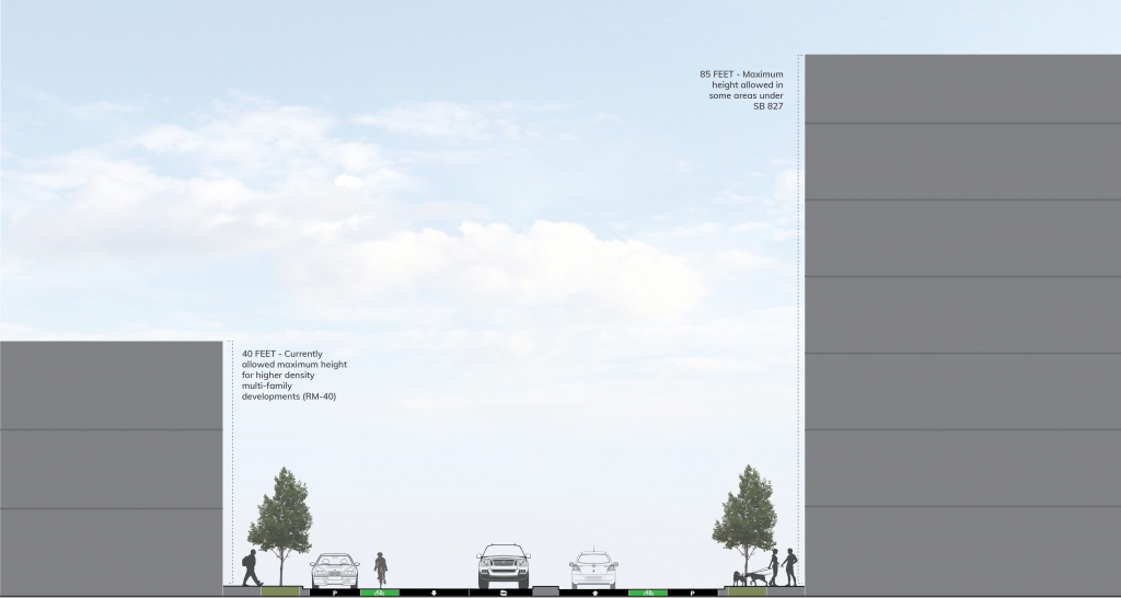
Example of possible changes in allowable heights for a multifamily development in Palo Alto.
EAST PALO ALTO IMPACTS
Currently, it appears that SamTrans Route 281 along University Ave qualifies as a high quality transit corridor, given the route’s morning and evening frequency. If this route does indeed continue to qualify as a high quality transit corridor, approximately 1,870 parcels in East Palo Alto would be included within a “Transit Rich Housing Development” area, out of about 4,600 total parcels in the city currently. This represents about 40% of the total number of parcels, or about 31% of East Palo Alto’s total land area. Changes from SB 827 would affect mostly commercial, mixed use, and multifamily zones along University Ave, but also single-family zones along Bay Rd and Newbridge St.
Parking
Parcels in Transit Rich Housing Project areas would also be affected by a removal in any minimum off-street parking requirements. East Palo Alto currently has minimum requirements for housing developments based on the number of units and unit type (for example, 1 space per 1-bedroom apartment unit).
Building Heights
East Palo Alto is undergoing an update to the zoning code, which will change zoning district designations and allowable heights. Currently, maximum allowable heights in East Palo Alto allow for up to 75 feet in higher density multifamily zoning districts (R-UHD). Up to 60 feet is allowed in R-HD-5 Districts. For most other residential zones, maximum allowable heights are 30 feet. Further, in Mixed Use High Zones (MUH), buildings may be up to 100 feet. Given current maximum heights, SB 827 would allow for taller residential developments (up to 85 feet under the bill) in Transit Rich Housing Project areas. Possible changes include:
- Approximately 260 parcels (6% of total parcels) would have maximum allowable heights of 85 feet. These parcels are those along major roads, including University Ave and Bay Rd, where high density housing is currently allowed to be up to 75 feet in height. The change in allowable heights here would be minimum, but could affect transition areas to single family zones. Further, some areas along Newbridge St and Bay Rd, which are currently zoned for low density residential, would see an increase in maximum heights from 30 feet to 85 feet.
- 1,600 parcels (35% of total parcels) would have maximum allowable heights of 55 feet. These include parcels within ¼ of University Ave and Bay Rd, but not directly facing a major street.
MENLO PARK IMPACTS
As with Palo Alto, Menlo Park properties along Camino Real would be affected by SB 827, as would those parcels that are in proximity to SamTrans Route 281 along Newbridge St to the north, as well as the Menlo Park CalTrain stop. Given the presence of these transit corridors, approximately 3,450 parcels in Menlo Park could qualify as being in a “Transit Rich Housing Project” area, out of about 9,100 total parcels in the city currently. This represents about 38% of the total number of parcels in the city, or about 17% of Menlo Park’s total land area. Changes from SB 827 would affect mostly commercial, mixed use, and multifamily zones in Downtown Menlo Park, but also single-family zones along Ivy Dr and Newbridge St.
Parking
Parcels in Transit Rich Housing Project areas would also be affected by a removal in any minimum off-street parking requirements. Menlo Park currently has minimum requirements for housing developments based on the number of units and unit type (for example, generally 2 spaces per residential unit is required).
Building Heights
Currently, maximum allowable heights in most residential areas of Menlo Park do not exceed 30 feet. In some higher density zones, especially in areas covered by the Downtown Specific Area Plan (along Camino Real), allowable building heights may be 60 feet. Under SB 827, taller residential developments up to 85 feet would be allowed in parts of Menlo Park, specifically along the Camino Real Corridor, along parts of Santa Cruz Ave, and parts of Ravenswood Ave. Sections of Willow Rd and Ivy Dr could also be affected.
Possible changes include:
- Approximately 310 parcels (3%) would have maximum allowable heights of 85 feet. These parcels are those along major roads including El Camino Real, and parts of Santa Cruz Ave and Ravenswood Ave.
- 2,780 parcels (31%) would have maximum allowable heights of 55 feet. These include parcels within ¼ of El Camino Real, but not directly facing a major street.
- 330 parcels (4%) would have maximum allowable heights of 45 feet. Parcels affected would include those outside of a High Quality Transit Corridor but with ½ mile of a major Transit Stop – primarily areas along just south of Middlefield Rd.
ATHERTON IMPACTS
Atherton shares the same higher quality transit corridor along Camino Real with Menlo Park and Palo Alto. In addition, there is one CalTrain Stop in Atherton, which qualifies as a major transit stop. Approximately 710 parcels in Atherton could qualify as being in a “Transit Rich Housing Project” area, out of about 2,600 total parcels. This represents about 27% of the total number of parcels in the city, or about 19% of Atherton’s total land area. Changes by SB 827 would have the most noticeable impact on Atherton given that the community mostly consists of single family homes.
Building Heights
As a mostly single-family home community, Atherton’s maximum heights and density requirements would be greatly affected by SB 827. Currently, maximum allowable heights do not exceed 34 feet in any zoning district, and maximum density is generally 1 unit per lot. In terms of height, possible changes include:
- Approximately 90 parcels (3.5%) would have maximum allowable heights of 85 feet. These parcels are those along El Camino Real.
- 450 parcels (17.2%) would have maximum allowable heights of 55 feet. These include parcels within ¼ of El Camino Real, but not directly facing a major street.
- 170 parcels (6.7%) would have maximum allowable heights of 45 feet. Parcels affected would include those outside of a High Quality Transit Corridor but with ½ mile of a major Transit Stop – primarily areas along just south of Middlefield Rd.
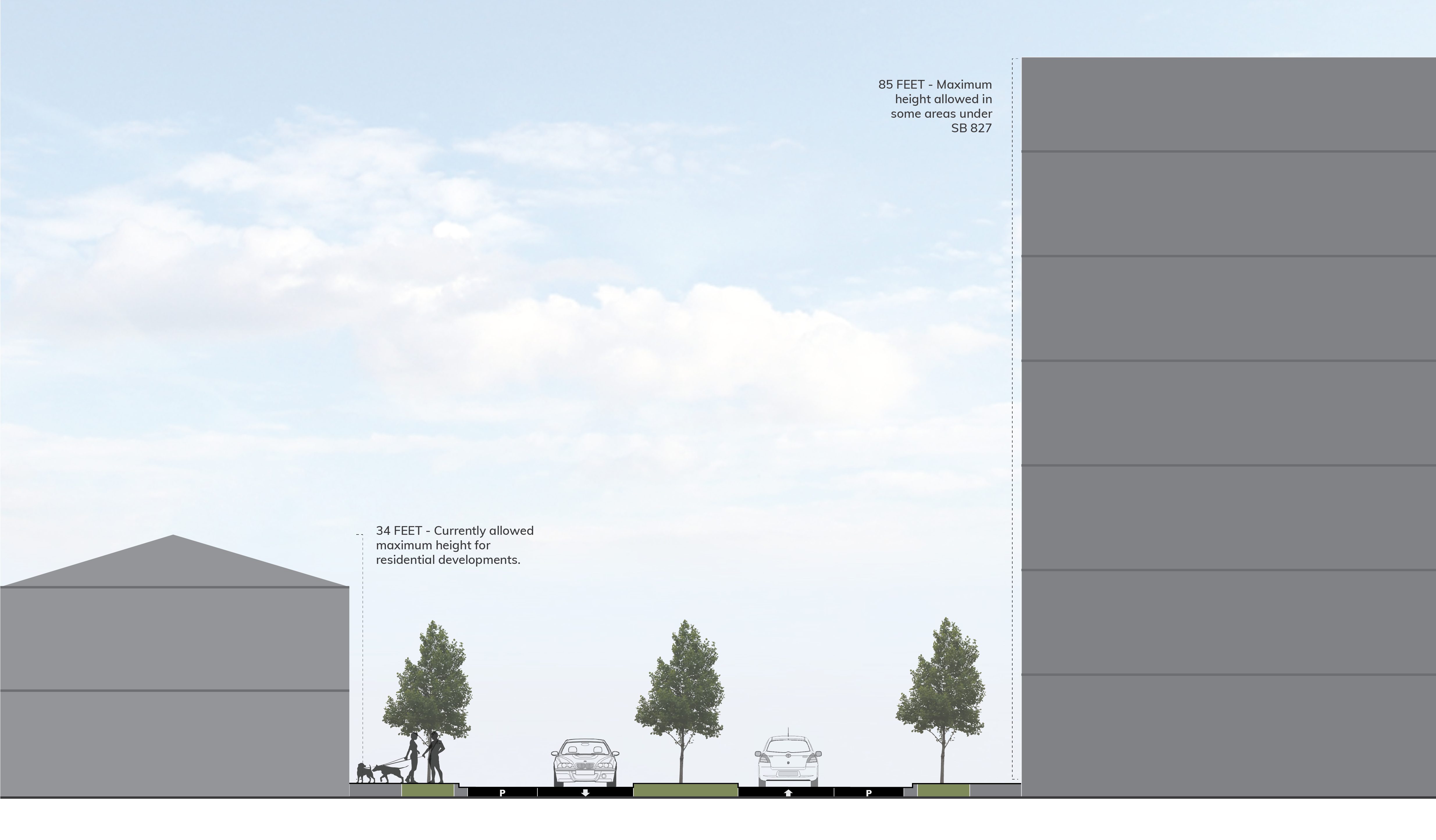
Example of multifamily development possible under SB 827 in Atherton.
NOTES & SOURCES
- This excludes parcels that designate condos or other properties within a larger main property to minimize double-counting of parcels sharing the same land area.
- This is excluding parcels that encompass water areas. A large amount of Palo Alto’s land area includes open space areas to the south including the Monte Bello Open Space Preserve. This explains the smaller area percentages relative to total number of parcels.
- https://mtc.ca.gov/our-work/plans-projects/focused-growth-livable-communities/priority-development-areas
- Data Sources: City of Palo Alto GIS Data Portal; City of Menlo Park GIS Data Portal; MTC Open Data Portal; Santa Clara County GIS Portal; San Mateo County GIS Portal